J. Sci. Technol. Environ. Inform. | Volume 07, Issue 02, 544-554| https://doi.org/10.18801/jstei.070219.56
Article type: Research article, Received: 19.02.2019, Revised: 16.05.2019, Date of Publication: 25 June 2019, Article updated: 09 August 2019.
Article type: Research article, Received: 19.02.2019, Revised: 16.05.2019, Date of Publication: 25 June 2019, Article updated: 09 August 2019.
Land cover and land use change detection by using remote sensing and GIS in Himchari National Park (HNP), Cox’s Bazar, Bangladesh
Saddam Hossen, Mohammed Kamal Hossain and Mohammad Fahim Uddin
Institute of Forestry and Environmental Sciences, University of Chittagong, Chittagong-4331, Bangladesh.
Institute of Forestry and Environmental Sciences, University of Chittagong, Chittagong-4331, Bangladesh.
Abstract
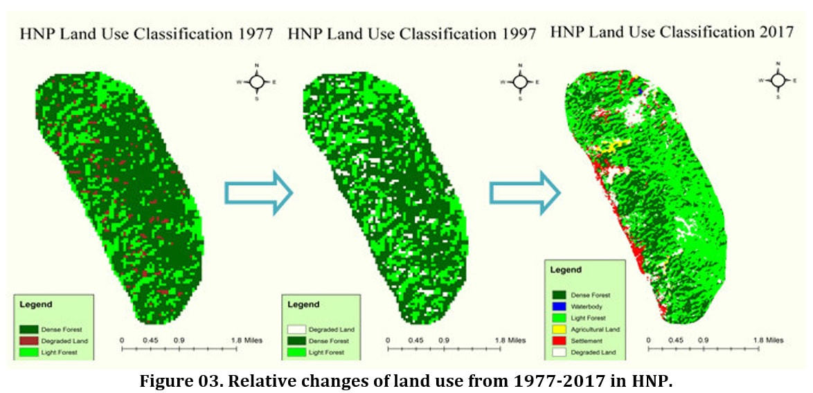
Himchari National Park (HNP) is a protected area that has been degraded, fragmented and converted severely into various land uses. In this study, land use changes of HNP were assessed from 1977 to 2017 by using Landsat 8 OLI-TIRS, Landsat 5 TM and Landsat 2 MSS satellite imagery. The ArcGIS v10.4 and ERDAS Imagine v15 software were used to process satellite imageries and assessed quantitative data for land use change assessment of this study area. Maximum likelihood classification algorithm was used for the assessment of supervised land use classification. Spatial and temporal dynamics of land use/cover changes (1977-2017) were quantified using three Satellite/Landsat images, a supervised classification algorithm and the post classification change detection technique in GIS. Some negative changes of land uses were showed from 1997-2017; but land use changes pattern from 1997-2017 showed comparatively better changes than 1977-1997 time period. But overall land use changes from 1977-2017 showed Dense Forest (529.4 ha) tends to degraded; agriculture (20.1 ha), degraded land (232.4 ha), settlement (82 ha), light forest (192.6 ha) and water body (2.2 ha) were increased. For the next 20 years of land use/cover changes, it is predict that more than 27.59% dense forest (145.83ha) will be decreased; on the other hand, 20% agriculture (4.02 ha), 9.86% degraded land (35.49 ha), 20 % settlement (16.40ha), 12.17% l light forest (89.47 ha) and 20% water body (0.45 ha) will be increased in 2037. The overall supervised classification accuracy was found 88.64% for 2017, 85.19% for 1997, and 87.67% for 1977 with Kappa values of 0.812, 0.71, and 0.78 for 2017, 1997, and 1977 respectively and these were fairly satisfactory. The present study is suggested for the sustainable management, protection, conservation and proper utilization of the natural resources of HNP.
Key Words
Land use, Remote sensing, Change detection, GIS, Satellite Imagery and Conservation
Article Full-Text PDF
| 56.02.07.19_version_2_land_cover_and_land_use_change_detection_by_using_remote_sensing_and_gis_in_himchari_national_park_cox_bazar_bangladesh.pdf |
|
Share This Article
|
|
Article Citations
MLA
Hossen et al. ‘’Land cover and land use change detection by using Remote Sensing and GIS in Himchari National Park (HNP), Cox’s Bazar, Bangladesh’’. Journal of Science, Technology and Environment Informatics 07(02) (2019): 544-554.
APA
Hossen S, Hossain M. K. and Uddin. M. F. (2019). Land cover and land use change detection by using remote sensing and GIS in Himchari National Park (HNP), Cox’s Bazar, Bangladesh. Journal of Science, Technology and Environment Informatics, 07(02), 544-554.
Chicago
Hossen S, Hossain M. K. and Uddin. M. F. ‘’Land cover and land use change detection by using remote sensing and GIS in Himchari National Park (HNP), Cox’s Bazar, Bangladesh’’. Journal of Science, Technology and Environment Informatics 07(02) (2019): 544-554.
Harvard
Hossen S, Hossain M. K. and Uddin. M. F. 2019. Land cover and land use change detection by using remote sensing and GIS in Himchari National Park (HNP), Cox’s Bazar, Bangladesh. Journal of Science, Technology and Environment Informatics, 07(02), pp. 544-554.
Vancouver
Hossen S, Hossain MK and Uddin. M. F. Land cover and land use change detection by using remote sensing and GIS in Himchari National Park (HNP), Cox’s Bazar, Bangladesh. Journal of Science, Technology and Environment Informatics. 2019 June 07(02): 544-554.
References
- Afify, H. A. (2011). Evaluation of change detection techniques for monitoring landcover changes:a case study in new Burg El-Arab area. Alexandria Eng. J. 50, 187–195. https://doi.org/10.1016/j.aej.2011.06.001
- Aspinall, R. (2004). Modelling land use change with generalized linear models–A multi-model analysis of change between 1860 and 2000 in Gallatin Valley, Montana. J. Environ. Manage., 72, 91–103. https://doi.org/10.1016/j.jenvman.2004.02.009
- Cardille, J. A. and Foley, J. A. (2003). Agricultural land-use change in Brazilian Amazonia between 1980 and 1995: evidence from integrated satellite and censu data. Remote Sensing of Environment, 87(4), 551-562. https://doi.org/10.1016/j.rse.2002.09.001
- Carlson, T. N. and Azofeifa S. G. A. (1999). Satellite Remote Sensing of land Use changes in and around San Jose´, Costa Rica. Remote Sensing of Environment, 70, 247–256. https://doi.org/10.1016/S0034-4257(99)00018-8
- Dewan, A. M. and Yamaguchi, Y. (2009a). Using remote sensing and GIS to detect and monitor land use and land cover change in Dhaka Metropolitan of Bangladesh during 1960–2005. Environ. Monit. Assess., 150, 237–249. https://doi.org/10.1007/s10661-008-0226-5
- Dewan, A. M. and Yamaguchi, Y. (2009). Land use and land cover change in Greater Dhaka, Bangladesh: using remote sensing to promote sustainable urbanization. Applied Geography., 29, 390–401. https://doi.org/10.1016/j.apgeog.2008.12.005
- Dutta, D., Kundu, A., Patel, N. R., Saha, S. K. and Siddiqui, A. R. (2015). Assessment of agricultural drought in Rajasthan (India) using remote sensing derived Vegetation Condition Index (VCI) and Standardized Precipitation Index (SPI). The Egyptian Journal of Remote Sensing and Space Science , 18, 53–63. https://doi.org/10.1016/j.ejrs.2015.03.006
- Dwivedi, R. S., Sreenivas, K. and Ramana, K. V. (2005). Land-use/land-cover change analysis in part of Ethiopia using Landsat Thematic Mapper data. International Journal of Remote Sensing, 26 (7), 1285-1287. https://doi.org/10.1080/01431160512331337763
- Fan, F., Weng, Q. and Wang Y. (2007). Land use land cover change in Guangzhou, China, from 1998 to 2003, based on Landsat TM/ETM+ imagery. Sensors, 7, 1323-1342. https://doi.org/10.3390/s7071323
- Guerschman, J. P., Paruelo, J. M., Bela, C. D., Giallorenzi, M. C. and Pacin, F. (2003). Land cover classification in the Argentine Pampas using multi-temporal Landsat TM data. International Journal of Remote Sensing, 24, 3381–3402. https://doi.org/10.1080/0143116021000021288
- Islam, K., Jashimuddin, M., Nath, B. and Nath, T. K. (2017). Land use classification and change detection by using multi-temporal remotely sensed imagery: The case of Chunati wildlife sanctuary, Bangladesh. The Egyptian Journal of Remote Sensing and Space Sciences, 21, 37–47. https://doi.org/10.1016/j.ejrs.2016.12.005
- Lambin, E. F., Turner, B. L., Geist, H. J., Agbola, S. B., Angelsen, A., Folke, C., Bruce, J. W., Coomes, O. T, Dirzo, R., George, P. S., Homewood, K., Imbernon, J., Leemans, R., Li. X., Moran, E. F., Mortimore, M., Ramakrishnan, P. S., Richards, J. F., Steffen, W., Stone, G. D., Svedin, U. and Veldkamp, T. A. (2001). The causes of land-use and landcover change: moving beyond the myths. Global Environ. Change, 11, 261–269. https://doi.org/10.1016/S0959-3780(01)00007-3
- Landis, J. R. and Koch, G. G. (1977). An Application of Hierarchical Kappa-type Statistics Assessment of Majority Agreement among Multiple Observers. Biometrics, 33, 363. https://doi.org/10.2307/2529786
- López-Serrano, P. M, Corral-Rivas, J. J., Díaz-Varela, R. A., Álvarez-González, J. G., López-Sánchez, C. A. (2016). Evaluation of radiometric and atmospheric correction algorithms for aboveground forest biomass estimation using landsat 5 TM data. Remote Sens., 8, 1-19. https://doi.org/10.3390/rs8050369
- Mallick, J., Kant, Y. and Bharath, B. D. (2008). Estimation of land surface temperature over Delhi using Landsat-7 ETM +. J. Ind. Geophys. Union, 12 (3), 131–140.
- Mamun, A., Al, Mahmood, A. and Rahman, M. (2013). Identification and Monitoring the Change of Land Use Pattern Using Remote Sensing and GIS: A Case Study of Dhaka City. IOSR Journal of Mechanical and Civil Engineering, 6(2), 20-28. https://doi.org/10.9790/1684-0622028
- Mas, J. F., Velazquez, A., Gallegos, J. R. D., Saucedo, R. M., Alcantare, C., Bocco, G., Castro, R., Fernandez, T. and Vega, A. P. (2004). Assessing land use/cover changes: a nationwide multidate spatial database for Mexico. International Journal of Applied Earth Observation and Geoinformation , 5, 249 261. https://doi.org/10.1016/j.jag.2004.06.002
- Meyer, W.B. (1995). Past and present land use and land cover in the USA. Consequences, 1, 25-33.
- Muttitanon, W. and Tiıpathi, N. K. (2005). Land use/land cover changes in the coastal zone of Ban Don Bay, Thailand using Landsat 5 TM data. International Journal of Remote Sensing, 26 (11), 2311- 2323. https://doi.org/10.1080/0143116051233132666
- Rawat, J. S., Biswas, V. and Kumar, M. (2013). Changes in land use/cover using geospatial techniques: a case study of Ramnagar town area, district Nainital, Uttarakhand, India. The Egyptian Journal of Remote Sensing and Space Science, 16, 111–117. https://doi.org/10.1016/j.ejrs.2013.04.002
- Rawat, J. S. and Kumar, M. (2015). Monitoring land use/cover change using remote sensing and GIS techniques: a case study of Hawalbagh block, district Almora, Uttarakhand, India. The Egyptian Journal of Remote Sensing and Space Science, 18, 77–84. https://doi.org/10.1016/j.ejrs.2015.02.002
- Riebsame, W. E., Meyer, W. B. and Turner, B. L. (1994). Modeling land use and cover as part of global environmental change. Clim. Change, 28, 45-64. https://doi.org/10.1007/BF01094100
- Rogana, J. and Chen, D. (2004). Remote sensing technology for mapping and monitoring land-cover and landuse change. Progress in Planning, 61, 301–325. https://doi.org/10.1016/S0305-9006(03)00066-7
- Seto, K. C., Woodcock, C. E., Song, C., Huang, X., Lu, J. and Kaufmann, R. K. (2002). Monitoring land use change in the Pearl River Delta using Landsat TM. International. Journal of Remote Sensing, 23(10), 1985-2004. https://doi.org/10.1080/01431160110075532
- Ulbricht, K. A. and Heckendorf, W. D. (1998). Satellite images for recognition of landscape and land use changes. ISPRS Journal of Photogrammetry & Remote Sensing, 53, 235-243. https://doi.org/10.1016/S0924-2716(98)00006-9
- Van Vliet, J., Bregt, A. K. and Hagen-Zanker, A. (2011). Revisiting Kappa to account for change in the accuracy assessment of land-use change models. Ecological Modelling, 222 (8), 1367-1375. https://doi.org/10.1016/j.ecolmodel.2011.01.017
- Veldkamp, A. and Lambin, E. (2001). Predicting land-use change. Agriculture, Ecosystems & Environment, 85,1–6. https://doi.org/10.1016/S0167-8809(01)00199-2
- Verburg, P., Schot, P., Dijst, M. and Veldkamp, A. (2004). Land use change modelling: curren practice and research priorities. GeoJournal, 61, 309–324. https://doi.org/10.1007/s10708-004-4946-y
- Vescovi, F. D., Park, S. J. and Vlek, P. L. (2002). Detection of human-induced land cover changes in a savannah landscape in Ghana: I. Change detection and quantification. In 2nd Workshop of the EARSeL Special Interest Group on Remote Sensing for Developing Countries. Bonn, Germany.
- Wang, L., Chen, J., Gong, P., Shimazaki, H. and Tamura, M. (2009). Land cover change detection with a cross-correlogram spectral matching algorithm. International Journal of Remote Sensensing, 30 (12), 3259–3273. https://doi.org/10.1080/01431160802562164
- Wu, Q., Li, H. Q., Wang, R. S., Paulussen, J., He, H., Wang, M., Wang, B. H. and Wang, Z. (2006). Monitoring and predicting land use change in Beijing using remote sensing and GIS. Landscape and Urban Planning, 78,322–333. https://doi.org/10.1016/j.landurbplan.2005.10.002
- Yang, X. and Lo, C. P. (2002). Using a time series of satellite imagery to detect land use and land cover changes in the Atlanta, Georgia metropolitan area. International Journal of Remote Sensensing, 23 (9), 1775–1798. https://doi.org/10.1080/01431160110075802
- Zeng, Y. N., Wu. G. P., Zhan, F. B. and Zhang, H. H. (2008). Modeling spatial land use pattern using autologistic regression. The International Archives of the Photogrammetry, Remote Sensing and Spatial Information Sciences, XXXVII, 115–118.
- Zhan, X., Sohlberg, R. A., Townshend, J. R. G. A. C. D., Carroll, M. L., Eastman, J. C. and Hansen, M. C. (2002). Detection of land cover changes using MODIS 250 m data – Google zoeken. Remote Sens.Environ., 83, 336–350. https://doi.org/10.1016/S0034-4257(02)00081-0
- Zhao, G.X., Lin, G. and Warner, T. (2004). Using Thematic Mapper data for change detection and sustainable use of cultivated land: a case study in the Yellow River delta, China. International. Journal of Remote Sensing, 25(13), 2509-2522. https://doi.org/10.1080/01431160310001619571
- Zsuzsanna, D., Bartholy, J., Pongracz, R. and Barcza, Z. ( 2005). Analysis of land-use/land-cover change in the Carpathian region based on remote sensing techniques. Physics and Chemistry of Earth, 30, 109-115. https://doi.org/10.1016/j.pce.2004.08.017
© 2019 The Authors. This article is freely available for anyone to read, share, download, print, permitted for unrestricted use and build upon, provided that the original author(s) and publisher are given due credit. All Published articles are distributed under the Creative Commons Attribution 4.0 International License.
Journal of Science, Technology and Environment Informatics, EISSN 2409-7632.